

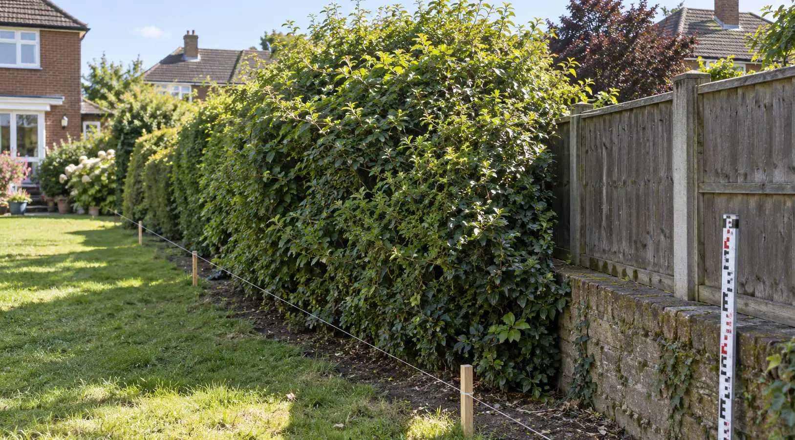
The Land Registry plan shows a straight line. Your garden shows a hedge that clearly bulges several feet past where that line supposedly runs. One of these is wrong, or so it feels standing in the garden — except that’s not quite how boundary law works, and understanding why is more useful than picking a side. This article covers the position in England and Wales, where HM Land Registry operates; Scotland and Northern Ireland have their own separate land registration systems and, in places, different legal presumptions.
A legal boundary and a physical feature are not the same thing, even when they usually agree
HM Land Registry draws a careful distinction here: a legal boundary is an invisible, exact line with no thickness, while a physical feature — a fence, wall or hedge — is simply what happens to be standing roughly where that line runs. They coincide often enough that most people never notice the difference exists. They don’t have to coincide, and over time, plenty of reasons can pull them apart: a fence rebuilt slightly off its original line, a wall that’s leaned for decades, or a hedge that has simply spread.
That last one surprises people. A mature hedge can widen enormously over the decades through ordinary growth, encroaching on the very land it originally just marked. HM Land Registry’s guidance on property boundaries specifically acknowledges that an untended hedge can spread, take root where it touches the ground and become so wide that its original line is difficult to identify. The fact that a hedge is wide today doesn’t mean the legal boundary has moved to match it — it may simply mean the hedge has grown into land on one side or the other, which is a different question from establishing where the legal line sits.
The title plan itself can be equally misleading if it’s read as an exact survey of the boundary. Most registered land in England and Wales is subject to the general boundaries rule under section 60 of the Land Registration Act 2002, meaning the red edging normally identifies the general position rather than the precise legal line. HM Land Registry doesn’t investigate every boundary down to the last centimetre when a property is first registered, and it expressly says there is no standard measurement or tolerance between the general boundary shown on a title plan and its precise position on the ground. So a fence sitting 40 centimetres away from where the red line appears to run isn’t automatically in the wrong place. There is no universal 20-centimetre or half-metre allowance either; the point is that the plan was never intended to settle that degree of precision on its own.
Walls and fences bring their own misleading clues. A wall might have been constructed entirely within one owner’s land, with the legal boundary running along one side rather than through its centre. And the familiar assumption that a fence belongs to whichever neighbour has the posts and rails facing them has no general legal foundation. These features can be useful evidence of an established boundary, particularly where they are old, but their appearance or construction isn’t a substitute for working out what land the original documents actually conveyed.
The hedge and ditch rule — genuinely old, genuinely still used
Where a boundary runs along a hedge with a ditch beside it, the law in England and Wales applies a presumption dating back to an 1810 case, Vowles v Miller: the boundary is taken to run along the far edge of the ditch from the hedge, not down the middle of either. The reasoning, as the judge put it at the time, is that a person digging a ditch along their own boundary would naturally dig right up to the edge of their land and throw the spoil back onto their own side — and then, often, plant a hedge on that resulting bank.
It sounds almost too neat to be real law, but the Court of Appeal reaffirmed the principle in Parmar v Upton [2015] EWCA Civ 795, confirming that it remains relevant to modern boundary disputes. It is a rebuttable presumption rather than an automatic rule, however, and its underlying history matters. The principle may not apply where the ditch is natural rather than deliberately dug, or where the hedge and ditch were created while both sides were in common ownership, because in that situation there was no boundary between two separate owners for the person digging to respect. It applies most naturally to agricultural land, although an old hedge-and-ditch boundary can remain relevant when the surrounding land has subsequently been developed for housing.
Scotland doesn’t apply this English hedge-and-ditch presumption, and its treatment of boundary features follows its own property law. That is an important distinction for anyone comparing general advice found online with a dispute involving Scottish land.
There’s a related, less formalised convention for fences bordering open or common land: where land is enclosed with a fence against waste ground or a highway, the fence may be presumed to belong to whoever enclosed it. Like the hedge-and-ditch rule, this is a starting point capable of being displaced by stronger evidence, not a guarantee that one neighbour owns the boundary feature. Neither convention should be used to settle a dispute without considering how the boundary came into existence in the first place.
What actually carries weight when the two disagree
Where the physical feature and the title plan genuinely conflict, the most important evidence will often be the original pre-registration conveyance or transfer — the document that first created the boundary — including its written description and any accompanying plan. Physical features that existed when that document was drawn up can be particularly valuable because they help explain what the parties understood they were buying and selling. The modern Land Registry title plan, useful for orientation, cannot necessarily settle the precise line because of the general boundaries rule. This isn’t a rigid hierarchy in which one piece of evidence automatically defeats everything else; the task is to interpret the relevant conveyance as a whole and understand the boundary it was intended to establish.
An old deed might describe the land by reference to a particular wall, hedge or ditch, for example, making the position of that feature at the time significant. A plan marked ‘for identification purposes only’ isn’t automatically worthless, either — it still forms part of the material to be considered alongside the written description and other evidence. Equally, a modern fence may be standing in a slightly different position from the one it replaced, something that would never be apparent from looking at today’s garden alone.
Old photographs can help build this picture, particularly if they’re genuinely datable and show the boundary feature in a materially different position from today. Historic plans, surviving fence posts, an old bank or a ditch that has partly disappeared may offer similar clues. On their own, though, a single photograph or a few old posts rarely settle anything — they’re corroborating evidence, weighed alongside the documents, not a trump card.
The age of a boundary feature is another point worth treating carefully. A fence that has followed the same dog-leg for forty years may be strong evidence of where the boundary was understood to run, especially if it existed when the relevant land was divided. But there’s no universal rule that a fence becomes the legal boundary merely because it’s been there for a particular number of years. Longstanding occupation of land beyond the original legal boundary can raise a separate issue of adverse possession, depending on the circumstances, but that is a different legal question from simply deciding whether an old fence or hedge matches the line on a title plan.
What to do if yours doesn’t line up
Don’t assume the fence is automatically wrong just because it doesn’t match the plan, and don’t assume the plan is automatically wrong just because the fence has clearly been there for decades. Pull the original conveyance if you can get hold of it — through your solicitor’s file from when you bought, or by checking whether HM Land Registry holds a copy of the relevant document. You can request copies of deeds and other property documents where they’re available, and the wording of an original transfer may tell you considerably more about the boundary than the red line on the modern title plan.
The next step is to compare that paperwork with what exists, and what used to exist, on the ground. If today’s fence replaced an earlier one, try to establish where the previous structure stood. If a hedge has widened substantially, look for evidence of its original bank or planting line. Where a ditch is involved, find out whether it’s artificial, how old it is and whether the hedge-and-ditch presumption is actually relevant before assuming the ditch belongs to one neighbour or should be shared. Old photographs and conveyances can sometimes resolve a discrepancy that appears much more serious when viewed only through the modern title plan.
Nor does every mismatch need correcting at HM Land Registry. Some uncertainty is built into the general boundaries system, and a fence that doesn’t trace the red edging perfectly isn’t, by itself, evidence of an error in the register. Where the precise position genuinely matters, there are formal ways to establish or record greater certainty, including boundary agreements and determined-boundary applications, but those processes serve different purposes and aren’t automatically necessary simply because the garden looks slightly different from the paperwork.
If the discrepancy affects an extension, the sale of a property, an intended fence replacement or ownership of a valuable strip of land, the question deserves more careful attention. A surveyor experienced in boundary disputes may help interpret the plans and physical evidence, while a solicitor may be needed where legal ownership itself is contested. What neither professional can safely do is treat the modern title-plan line or the current fence position as conclusive without considering the evidence behind it.
And if the discrepancy is small and nobody’s actually disputing anything, it’s often perfectly reasonable to leave it exactly as it stands — plenty of boundaries in England and Wales have run slightly askew of the paperwork for a century without anyone needing to fix them. Sometimes the most sensible answer is understanding why the two lines differ, rather than turning a harmless discrepancy into a formal boundary dispute.
Important: This article provides general property information, not legal, financial, surveying or other professional advice for your individual circumstances. Boundary disputes can depend on historic documents, physical evidence, occupation of the land and the particular facts. If significant property rights or money are at risk, or you are considering moving a boundary feature or taking legal action, take appropriate professional advice before proceeding.