

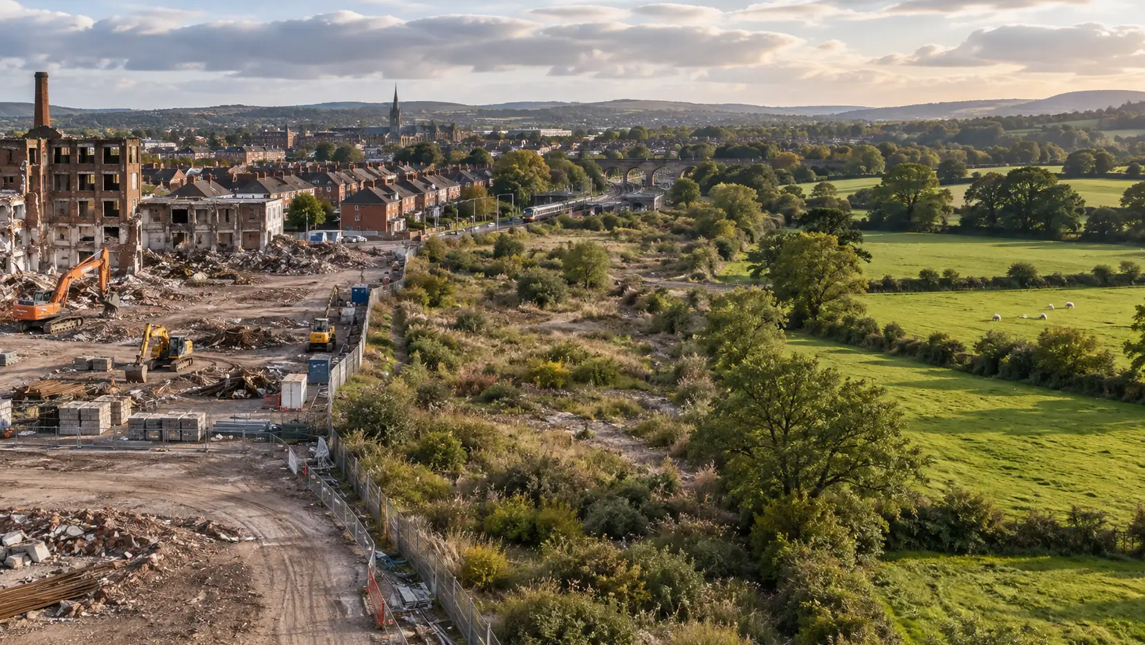
Most people, asked directly, hold several housing beliefs at once that feel obviously compatible until you try to build something: England needs more homes; the countryside should be protected; existing towns already feel congested enough; and brownfield land should be used before anything else is touched. Individually, none of these positions is unreasonable. Together, they run into a genuine practical limit — brownfield is an important part of the answer, but even current government planning policy recognises that it cannot meet identified housing need on its own. Government planning reforms on brownfield, grey belt and Green Belt
There is also an important distinction hidden in the title of this article: brownfield, Green Belt and grey belt are not three competing colours on one map. Brownfield describes land that has previously been developed. Green Belt is a planning designation. Grey belt is a policy category applied to land within the Green Belt. A brownfield site can therefore also sit inside the Green Belt and potentially fall within the grey-belt definition. Understanding that overlap makes much of the debate considerably easier to follow.
This article looks at what the main categories actually mean, and where the practical trade-offs sit. It focuses on England, where grey belt is a specific feature of national planning policy; Scotland, Wales and Northern Ireland operate separate planning frameworks, covered briefly at the end.
Policy last checked: 15 September 2026.
Brownfield: the obvious first choice, with real limits
Brownfield land — usually described in planning policy as previously developed land — is consistently prioritised, and it’s easy to understand why. Reusing land that’s already been developed can reduce pressure to expand into undeveloped countryside, bring derelict or under-used sites back into productive use and, where the location is right, make use of existing transport and services. Local authorities in England are required to maintain brownfield land registers identifying previously developed sites considered suitable for housing. GOV.UK guidance on brownfield land registers
The obvious follow-up question — why not simply build everything on brownfield and leave everywhere else alone — runs into several genuine constraints. Much brownfield land carries contamination, difficult ground conditions or obsolete structures from previous industrial or commercial uses, requiring expensive remediation before housing becomes possible. Ownership can be fragmented, particularly on larger former industrial sites. Some locations need substantial new infrastructure before they work as residential neighbourhoods, while others remain in productive employment or commercial use and aren’t simply empty sites waiting to be converted into homes.
Brownfield isn’t automatically in the right place either. A previously developed site poorly connected to employment, schools, public transport and other services may be a less sustainable location for substantial housing than undeveloped land on the edge of an existing settlement with strong transport connections.
Brownfield-first is a sound principle. It isn’t the same thing as saying every brownfield site is suitable, available, viable or capable of meeting England’s housing requirement on its own. That connects directly to our companion article Why Isn’t Britain Building Enough Homes?, because identifying land is only the first step; remediation, infrastructure, finance, planning and market demand still determine whether that land ultimately produces completed homes.
Green Belt: a planning tool, not a synonym for beautiful countryside
This is probably the single most common misconception in the entire debate, and it’s worth correcting directly. Green Belt is a specific planning designation — it isn’t a general label for beautiful countryside, valuable habitat or nationally important landscape.
The current National Planning Policy Framework retains five purposes for Green Belt land: checking the unrestricted sprawl of large built-up areas; preventing neighbouring towns from merging into one another; assisting in safeguarding the countryside from encroachment; preserving the setting and special character of historic towns; and assisting urban regeneration by encouraging the recycling of derelict and other urban land.
Notice what’s absent from that list. Green Belt status doesn’t, by itself, tell you that a particular field has exceptional ecological value, that its landscape is nationally important or that it contains protected habitat. Those interests can be protected through separate designations and policies, including National Parks, National Landscapes, Sites of Special Scientific Interest, ancient woodland and a range of heritage and habitat protections.
The practical consequence is genuinely counterintuitive. Visually unremarkable land can sit inside the Green Belt because of its strategic relationship with a town or city, while spectacular or ecologically important countryside can sit outside the Green Belt and be protected for completely different reasons.
This doesn’t mean public concern about developing open land is misplaced. It means the specific term “Green Belt” describes something narrower than “protected countryside” in general.
Grey belt: a specific planning test, not “low-quality Green Belt”
Grey belt entered national planning policy in December 2024, but the definition has already evolved through the revised National Planning Policy Framework published in August 2026. It is frequently summarised as “Green Belt land that isn’t very good and can now be built on”, which is an appealingly simple description and an inaccurate one.
Under the current framework, grey belt is land within the Green Belt comprising previously developed land and/or other land that does not strongly contribute to three particular Green Belt purposes: checking unrestricted urban sprawl, preventing neighbouring towns from merging, and preserving the setting and special character of historic towns.
Two of the five Green Belt purposes aren’t part of that classification test: safeguarding the countryside from encroachment and assisting urban regeneration. Grey belt is therefore not an assessment of whether land looks rural, attractive or environmentally valuable. It is an assessment of how strongly it performs particular strategic Green Belt functions.
There is an important 2026 change here. The December 2024 version of the policy excluded some land covered by other major environmental and heritage protections from the grey-belt definition itself. The August 2026 framework removed that automatic exclusion.
That doesn’t remove those protections. A site can now meet the technical grey-belt definition and still face a powerful or decisive planning constraint because it affects a National Landscape, protected habitat, ancient woodland, heritage asset, flood-risk area or another interest protected elsewhere in planning policy or law. Grey-belt status answers one question about the role land performs within the Green Belt; it doesn’t override every other reason development might be unacceptable.
Nor does being identified as grey belt mean planning permission is automatic. Wider planning considerations still apply, including transport, drainage, design, infrastructure, ecology and heritage, and the current framework retains tests around the effect development would have on the remaining Green Belt.
That distinction matters because “this land is grey belt” and “this land has been released for housing” are not interchangeable statements.
The “golden rules” attached to Green Belt housing
Where major housing development comes forward through the relevant Green Belt routes, current policy attaches what it calls the Golden Rules, covering affordable housing, necessary infrastructure improvements and new or improved publicly accessible green space.
The affordable-housing element is more nuanced than the often-repeated suggestion that every qualifying Green Belt scheme simply has to provide 50% affordable homes. Updated development plans can establish the applicable requirement. Until that happens, the national fallback generally increases the otherwise applicable affordable-housing requirement by 15 percentage points, subject to a 50% cap; where no existing requirement applies, the fallback is 50%.
This matters to both sides of the argument. For communities, Green Belt release isn’t intended simply to add market housing while existing infrastructure absorbs the consequences. Affordable homes, infrastructure and accessible green space form part of the policy bargain. For developers, those requirements have real costs and have to sit inside the same viability calculation as land, construction, finance and everything else involved in delivering the scheme.
The Golden Rules are therefore not a decorative set of promises attached after the principle of development has been decided. They form part of the economics of making major Green Belt housing acceptable under current policy.
Building near transport connections
A recurring theme in national planning policy is that if substantial numbers of homes have to be accommodated somewhere, locations with strong public transport connections have obvious advantages over places where almost every new journey will depend on a car.
The August 2026 NPPF strengthened that approach considerably, with government describing suitable housing within reasonable walking distance of well-connected rail, Underground, tram and light-rail stations as having a “default yes” in principle, alongside stronger expectations around minimum density. Government announcement on housing around well-connected stations
That affects the Green Belt debate because some highly accessible station locations sit on or close to existing Green Belt boundaries. National policy increasingly asks whether those places are making sufficiently intensive use of the transport infrastructure already available rather than assuming that their existing low density should remain unchanged indefinitely.
This doesn’t turn every station car park, suburban street or nearby field into an automatic housing site. Infrastructure capacity, design, local character, environmental constraints and the quality of the transport connection still matter. But it does mean that accessibility now weighs more heavily in the “where should the homes go?” question than it did only a few years ago.
Density: the option that’s easy to overlook
A meaningful part of housing need can also be met without extending settlements as far outward, through higher density on land already developed or already intended for development — building upward or making better use of existing urban land rather than simply moving the edge of the town further out.
That can mean redevelopment of low-density commercial land, homes above shops, infill, taller buildings in appropriate places and greater density around town centres and transport hubs. Density is sometimes discussed as though the choice were between suburban houses and tower blocks, but there is a substantial middle ground: terraces, mansion blocks, mid-rise apartments and mixed-use neighbourhoods can all accommodate considerably more people per hectare than conventional low-density estates without requiring high-rise development.
Higher density isn’t automatically right everywhere. It still needs good design, adequate amenity space and sufficient transport, schools, healthcare and other infrastructure, and there are practical limits to how much national housing need can be absorbed in this way.
But every additional home accommodated through better use of an existing settlement is one that doesn’t necessarily require the settlement to spread over as much additional land. The stronger 2026 emphasis on density around well-connected stations makes that part of the debate increasingly difficult to separate from the brownfield and Green Belt questions.
How this actually gets decided locally
National planning policy sets the broad framework, but it doesn’t normally select every individual housing site in England.
Local planning authorities prepare development plans that establish how their areas are expected to grow and which land should be allocated for housing and other uses. Under the new plan-making system introduced in 2026, those plans continue to involve evidence gathering, public engagement and independent examination before adoption. Planning Inspectorate guidance on the 2026 local-plan system
Choosing sites involves considerably more than looking at whether a parcel is labelled brownfield, grey belt or Green Belt. Authorities need to consider whether land is genuinely available, suitable and deliverable; what infrastructure it needs; what environmental constraints apply; how accessible it is; and how the combined pattern of sites fits the wider development strategy.
Individual planning applications are then assessed against the development plan, national policy and other material considerations.
“Where should the homes go?” is therefore answered at two connected levels. National policy establishes increasingly strong expectations around housing delivery, brownfield, transport accessibility, density and Green Belt assessment; local planning determines how those expectations translate into actual sites and actual settlement growth.
The argument over one field or redevelopment site sits inside a much larger decision about where a whole district, town or city is expected to accommodate change.
The devolved nations run different systems entirely
Grey belt, as described here, is specifically an English planning concept.
Scotland, Wales and Northern Ireland operate separate planning-policy frameworks with their own approaches to settlement growth, housing allocations and open land. Some use Green Belt terminology within their own systems, but that doesn’t make the English NPPF definition, grey-belt test or Golden Rules applicable there.
Applying England’s grey-belt classification to a Scottish, Welsh or Northern Irish site would therefore be a category error. Anyone assessing land outside England needs the relevant devolved framework rather than an England-focused explanation transplanted across the border.
Can these positions actually be reconciled?
Not perfectly, and not without trade-offs — but more than the binary “brownfield versus Green Belt” framing usually suggests.
Brownfield-first remains a sensible starting point, but brownfield isn’t an unlimited pool of immediately available housing sites. Some of it is contaminated, occupied, fragmented, poorly located or too expensive to unlock without substantial intervention.
Green Belt serves real and specific planning purposes, but it isn’t a ranking of landscape beauty or ecological importance. Grey belt doesn’t identify land that is environmentally worthless; it identifies land within the Green Belt that performs relatively weakly against three particular strategic purposes. Separate environmental, landscape and heritage protections still have to be applied whether the land is grey belt or not.
And, importantly, these categories overlap. Previously developed land can sit inside the Green Belt. Some of that land may fall within the grey-belt definition. The planning debate isn’t therefore a simple process of exhausting all the brown sites before reluctantly moving on to grey ones and then green ones.
Transport and density add further dimensions. A piece of undeveloped land beside a well-connected station may offer a more sustainable location for homes than a poorly connected brownfield site elsewhere, while substantial numbers of homes can sometimes be accommodated inside existing settlements by using land more intensively.
None of this makes the underlying political choice disappear. Every serious housing strategy changes somewhere. More density changes existing towns. Brownfield redevelopment can displace existing uses and require expensive remediation. Settlement expansion changes the edge of the countryside. Green Belt release changes land deliberately kept open for strategic planning reasons.
The useful question is therefore not simply whether a site is “brown”, “grey” or “green”. It is whether that particular land is a sustainable, deliverable and proportionate place for the homes an area needs once its planning role, environmental constraints, infrastructure, transport and realistic alternatives are considered together.
That doesn’t remove disagreement.
It at least means the disagreement is about the real trade-offs.
This article provides general information about land-use and housing policy in England and is not planning or legal advice for a particular site. Scotland, Wales and Northern Ireland operate separate planning frameworks. National and local planning policy can change, and individual sites may be subject to environmental, heritage, infrastructure and other constraints not apparent from their Green Belt or grey-belt status alone. Check the current development plan and national policy, and obtain appropriate professional planning advice where necessary.